
Tags
birthday, fog, foot trail, fun, hiking, Mount St. Helens, road trip
 Wow, it’s been a couple of weeks since I last posted in here! Everything is really busy and good these days…so much so I probably didn’t have a clue what to blog about last week.
So now…drum roll…last Sunday May 19 was my birthday (hence the name of this blog for those of you just tuning in), and I had THE most unique, wonderful and enjoyable celebration ever! J and I were talking about our birthdays a few weeks ago (his is in early May) and about other things we’d like to do later in the year. I mentioned how I’ve never been to Mount St. Helens and how happy I would be to have a chance to go check it out! And we thought, why not do it on my birthday? May 19 was one day after the 33rd anniversary of the big 1980 eruption.
I remember May 18, 1980 so well. It was the day before my 13th birthday, and my family and I had spent the weekend down on the Washington Coast in Ocean Park, a longtime favorite getaway spot for us on the Long Beach peninsula. It was a Sunday and we were driving home to the Seattle area. By the time we got to Raymond on Highway 101, traffic was at a complete stop and backed up for miles. What was going on? It was Sunday in a rural area of the state – why so many cars? Keep in mind, this was 1980 so we obviously didn’t have email, cell phones or other devices to keep us constantly updated with news. So, we turned on the radio and heard what happened. The highway was jammed due to traffic detours. The mountain had erupted around 8:30am that morning. Ash, rocks, mud and steam blasted miles up into the sky, and searing hot mudflows destroyed everything in their paths. Interestingly enough, the blast was lateral, as the entire north face of the mountain pretty much gave way after being pounded relentlessly by earthquakes for months. Millions of tons of ash blew eastward, so towns in central and eastern Washington were pitch black at high noon.
The mountain had reawakened earlier in 1980, smudging a near perfectly round snowy cap with an ash and steam blast, forming a new crater which continued to grow and grow. The news coverage about this was fairly decent, but it was not a top story by any means and to many went simply unnoticed. President Carter’s announcement of the Boycott of the summer Olympic games in Moscow was the big news.
Now before I get into more detail, you might be wondering…how the heck could we not know the eruption had occurred? Didn’t we hear or see anything? Was Seattle in any danger? To answer these questions, you have to remember that Mount St. Helens is in a rural area of Washington State. It’s about 100 miles south of Seattle and about a 3 hour drive from there by car. As tragic as the devastation to homes, roads, bridges and wildlife was (not to mention 57 human casualties), the destruction would have been far worse near a more populated part of the state. For many in the Seattle area, Mount St. Helens was mostly off our radar, except when it came time for spectacular camping and hiking, plus boating on nearby Spirit Lake. I’m sorry I never had the chance to visit it before the eruption – it looked postcard perfect.
J and I hit the road on Sunday, ready to blast down I-5. But first, we needed coffee! J doesn’t like patronizing big chains like Starbucks and prefers going to smaller Ma and Pa type coffee shops, but once we got on the road they were few and far between. We hopped off the freeway in Fife, hungry for caffeine. Fife is one of those places I’ve always blasted through on my way somewhere else, so it was interesting seeing what the town looks like. Actually, not really.
We ended up going through a Starbucks drive thru…and when we got back on the road J discovered his double tall latte was actually hot water with 3 honeys in it. Oops, they screwed up our order! We laughed it off and sipped “honey water” the whole way down. Meanwhile, I’m sure some poor soul was lamenting about getting a latte instead of their hot water and honey!
Then, we needed breakfast. We stopped in Lacey, not far from Olympia. J remembered a wonderful hole in the wall diner he really liked somewhere off the highway, but we couldn’t find it. Our hungry stomachs won out and we headed into the Hawks Prairie Casino. We weren’t thrilled with the idea of eating breakfast in a smoky environment (smoking is permitted in casinos as they are on Native American land and exempt from state no-smoking regulations), so we were pleasantly surprised that the restaurant was smoke free. Scrambled eggs, hashbrowns and lots of coffee!
We still had a way to go. Mount St. Helens is a good 50 miles or so east of I-5, after about a 2 hour drive south, so at minimum it’s a day trip from Seattle. We were headed to the Johnston Ridge Observatory, just 5 miles from the crater. The picture at the top of this post is the view we were waiting for!
Once we got off of I-5 and onto the two-lane highway headed east, it started getting interesting. Rural little towns and lots of forest. Places I’ve never driven through even after living in Washington State my whole life. I was so excited I could hardly stand it! Road trips make me giddy. Then we turned onto the Spirit Lake Highway, the last stretch of the trip. Cell phone signals went dead and we started climbing in elevation. The observatory is 4300′ up! Even the GPS didn’t have much to say. Then…FOG. Lots of it. We were driving through a thick cotton ball for probably a good half an hour. On a winding rural road headed up a mountain…let’s just say this gets your adrenaline flowing. We would zoom over bridges with no idea of what scenery we were missing or how high up the bridge was. I tried not to let my mind wander about that too much.
 When we arrived at Johnston Ridge and pulled into the parking lot, this was the view. The fog was so thick we felt discombobulated getting out of the car. And notice the snow! Silly me, I was a little surprised to see snow in mid May, but then again we’re up in the mountains! I couldn’t even see the other side of the parking lot, nor could I see where the observatory entrance was. I ended up asking the lady running a small concession stand out of a trailer in the lot where the entrance was – that’s how thick the fog was!
We were ready to check out the observatory and get in some hiking. There are quite a few trails with various levels of difficulty all around, and the views of the mountain are amazing. Although on Sunday we really had to use our imagination. The view from the observatory was nothing like the picture at the top of this post. Rather, it was just WHITE. FOG. Nothing. I was joking that you could take your picture with the whiteness behind you and then photoshop a picture of the mountain or anything else of your choice behind you later!
The observatory is run by the US Forest Service, and the guys are wonderful. Very helpful and friendly. They said they get about 300,000 visitors annually, from all over the world. Wow!
Once you are inside you can check out interactive displays of the volcano, watch a couple of movies and see tons of before and after pictures. This is all included in your $8 entrance fee; you’ll get a wrist band just like you’re in a nightclub. I joked that I should be able to get in free because it’s my birthday, but of course no such luck. Besides, the fees help cover costs of keeping the place open.
We went to a Ranger talk, and I highly recommend doing this. He was super enthusiastic and passionate, talking about the volcano and showing various pictures and answering questions. J and I even talked with him for about a half hour afterwards!
Then we were ready to get outside on the trails! The trails leaving the observatory are asphalt paved so it’s very easy to get around. Once you get further away the paving stops. Sadly, we never got that far.  We checked out the short trail headed up from the building which overlooks the parking lot. Short with switchbacks…and hardly anything to see except for the building below. Off to the left is a spectacular valley and the view of the mountain, which would normally dominate the skyline. Would Mother Nature lift the fog? Only time would tell. Some people we talked to had been hanging out since early in the morning waiting for it to clear up.
 This entire area is extremely fragile, as the ecosystem is slowly rebuilding, and the goal is to have minimal to no human interference with what nature is doing. What a treasure this volcanic monument and national forest is! That’s why the regulations for visitors are strict, and it’s important to do your homework and prepare ahead of time to avoid problems.
For example, pets are not permitted on the trails or anywhere in the observatory. Make arrangements for them to be cared for at home. You’ll also want to bring your own food and plenty of water. There are no restaurants or vending machines at Johnston Ridge. (Also, no food is permitted inside the observatory). J and I had lunch in the parking lot, enjoying wonderful BBQ’d chicken he had prepared the night before. Killer marinade!
You also need to stay on the trails. This is not only for safety but also to avoid treading on nature’s rebuilding processes. “Plants grow by the inch and die by the foot” say the warning signs. Also, don’t touch or try to take home rocks as souvenirs. You’ll be heavily fined.
We headed downhill on the paved trail into the valley…but after just about 1/4 of a mile we had to turn back. SNOW blocked the trail at a steep, sloped angle, leading to a 1000′ drop off down into the foggy valley. No thanks! But it made us long for next time…we learned how the valley floor is filled with wildflowers and shrubs in the summer time. The valley was once old timber forest – flattened or swept away in the blast within seconds.
Around 4:30pm we decided to head back to make sure we were heading home in daylight. Sure enough, the fog started lifting! Just enough of a tease to see the valley, not the mountain herself.
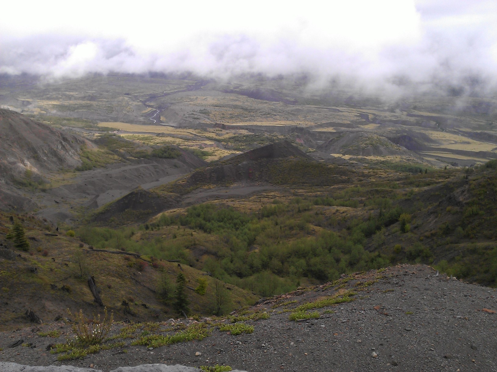
The picture below is one of my favorites from this trip. This was taken from a lookout a short drive downhill from the observatory looking down into the valley. You can see the start of the Toutle River just to the left of center. This entire area looked like the moon after the eruption, and it’s astonishing how much wildlife and plants are slowly returning.
The mountain is hiding behind the thick clouds, tempting us for our next visit.

Pingback: Suburban Surprise | fivenineteen